


Saara- Estrutura de Richat - Mauritânia - 3min.
Estrutura de Richat - Mauritânia - 7min
40s.
Olho da África - 1min.
Projeto Lençois - Saara - 7min.
Áfria, Continente Fantástico - 7min.
Saara à pé - 15min.
Música Mauritânia - Sahara 45 - 3min.
Estrutura de Richat
Origem: Wikipédia, a enciclopédia livre.

Descoberta
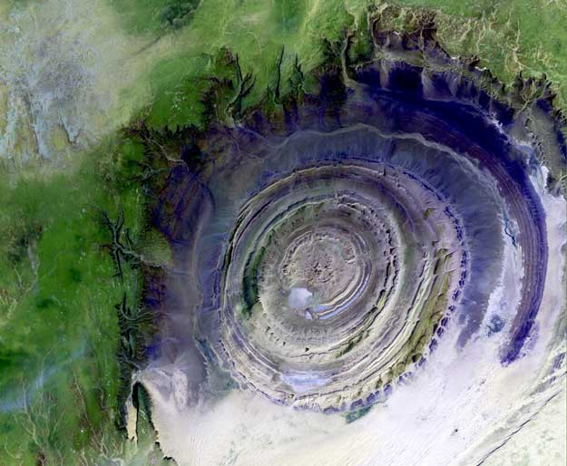
A estrutura foi descrita pela primeira vez nos mapas na escala de 1/200 000 feitos pelo Instituto Geográfico Nacional Francês, em 1963. A partir daí ela atraiu a atenção das primeiras missões espaciais, devido à sua forma característica em forma de oculus, numa paisagem desértica sem qualquer outro destaque.Descrita por alguns como uma amonite gigantesco no deserto, a estrutura, que tem um diâmetro de quase 55 km e desníveis de cerca de 300 a 400 m, tornou-se uma espécie de ponto de encontro para as tripulações dos ônibus espaciais.
Outras imagens

Baixar imagem grande ( 121 KB , JPEG, 800x755 )
Esta característica circular proeminente no deserto do Saara da Mauritânia tem atraído a atenção desde as primeiras missões espaciais porque forma um alvo em evidência a extensão de outra forma bastante inexpressivo do deserto. Descrito por alguns como parecendo uma amonite descomunal no deserto , a estrutura [que tem um diâmetro de cerca de 50 quilômetros ( 30 milhas) ] se tornou um marco para as equipes de transporte. Inicialmente interpretada como uma estrutura de impacto de meteorito por causa de seu alto grau de circularidade , é agora pensado para ser apenas uma elevação simétrica ( anticlinal circular ) que foi exposto pela erosão. Quartzitos Paleozóico formar as camas resistentes delineando a estrutura .
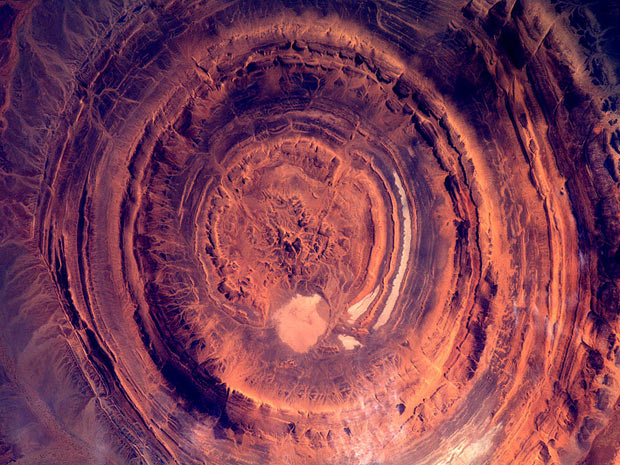
Esta imagem foi adquirida em 7 de Outubro de 2000, pelo Spaceborne avançado da emissão térmica e Radiometer Reflexão ( ASTER ) no satélite Terra, da NASA. Com os seus 14 bandas espectrais do visível para a região de comprimentos de onda do infravermelho termal , e sua alta resolução espacial de 15 a 90 metros ( cerca de 50 a 300 pés) , ASTER vai imagem da Terra para os próximos 6 anos para mapear e monitorar a superfície mudando de nosso planeta.
Imagem cedida pela NASA / GSFC / MITI / ERSDAC / JAROS e EUA / Japão ASTER Science Team
Estrutura Richat da Terra
Crédito: Landsat 7, USGS, NASA
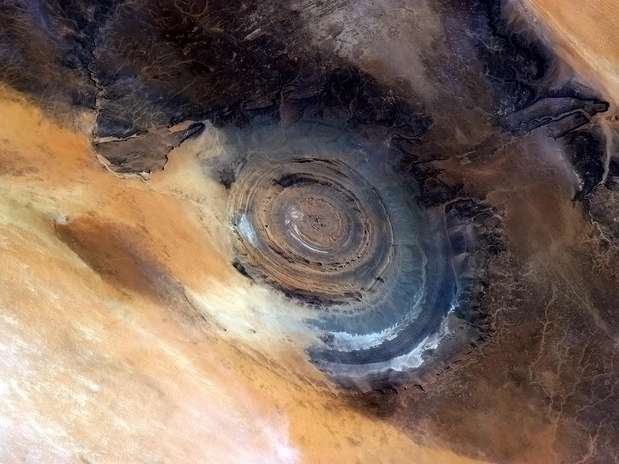
Explicação: O que na terra é isso? A Estrutura de Richat no deserto do Saara da Mauritânia é facilmente visível a partir do espaço, pois é cerca de 50 quilômetros de diâmetro. Uma vez pensado para ser uma cratera de impacto, meio e falta de rocha alterada-choque liso da estrutura Richat indique o contrário. A possibilidade de que a Estrutura de Richat foi formada por uma erupção vulcânica também parece improvável por causa da falta de uma cúpula de rocha ígnea ou vulcânica. Pelo contrário, a rocha sedimentar em camadas da estrutura Richat agora é considerado por muitos ter sido causado por rocha erguida esculpida pela erosão. A imagem acima foi capturado no ano passado pela órbita satélite Landsat 7. Por que a Estrutura de Richat é quase circular permanece um mistério.
"O Olho da Africa" foto feita da Estação Espacial Internacional
WikiMapia
I stumbled across this on Universe Today’s “Where in The Universe Challenge”
and thought it made a very interesting geologic phenomenon to write
about. (Apologies to Ron and the gang for potentially stealing an idea
from the Where on Google Earth challenge.)

Source: Google Earth
What does the above photograph look like on your first impression? I immediately said an impact crater and was amazed at how well defined this was. Especially when you find out this feature has a diameter of 30 kilometers!
This interesting feature is known as the Richat Structure and is located in the African country of Mauritania. Below is an embedded Google Maps frame showing the location.
View Larger Map
This structure is so big, that while zooming in to Mauritania on Google Maps, I was immediately able to see it on a rather zoomed out view.
- See more at: http://geology.rockbandit.net/2008/09/25/richat-structure-in-mauritania/#sthash.bhrt3ih2.dpuf
Richat Structure in Mauritania
I stumbled across this on Universe Today’s “Where in The Universe Challenge”
and thought it made a very interesting geologic phenomenon to write
about. (Apologies to Ron and the gang for potentially stealing an idea
from the Where on Google Earth challenge.)
Source: Google Earth
What does the above photograph look like on your first impression? I immediately said an impact crater and was amazed at how well defined this was. Especially when you find out this feature has a diameter of 30 kilometers!
This interesting feature is known as the Richat Structure and is located in the African country of Mauritania. Below is an embedded Google Maps frame showing the location.
View Larger Map
This structure is so big, that while zooming in to Mauritania on Google Maps, I was immediately able to see it on a rather zoomed out view.
Anyway, what exactly is this structure? It was originally thought to have been an impact crater when it was first seen on a large scale by scientists. More research eventually revealed that it was not actually an impact crater, but instead a a circular anticline whose crest has been eroded away.
Kim from All of My Faults Are Stress Related adds this comment after reading a paper linked in the Wikipedia article on the structure:

Source: Wikipedia – Anticline
According to the website Google Sightseeing, there are a few other similar looking features that can be found in Africa: The Jebel Uwaynat that borders Sudan, Egypt and Libya and the Brandberg Intrusion in Namibia.
[Via Universe Today]
More Information
- See more at: http://geology.rockbandit.net/2008/09/25/richat-structure-in-mauritania/#sthash.bhrt3ih2.dpufSource: Google Earth
What does the above photograph look like on your first impression? I immediately said an impact crater and was amazed at how well defined this was. Especially when you find out this feature has a diameter of 30 kilometers!
This interesting feature is known as the Richat Structure and is located in the African country of Mauritania. Below is an embedded Google Maps frame showing the location.
View Larger Map
This structure is so big, that while zooming in to Mauritania on Google Maps, I was immediately able to see it on a rather zoomed out view.
Anyway, what exactly is this structure? It was originally thought to have been an impact crater when it was first seen on a large scale by scientists. More research eventually revealed that it was not actually an impact crater, but instead a a circular anticline whose crest has been eroded away.
Kim from All of My Faults Are Stress Related adds this comment after reading a paper linked in the Wikipedia article on the structure:
It’s not just a circular anticline – it’s a dome above a Cretaceous pluton. (The article describes the intrusion as a plug, but I wonder if we’re not looking at the top of a laccolith – like the Henry Mountains in Utah, but not eroded through to the pluton itself.)The paper is titled “Resolving the Richat enigma: Doming and hydrothermal karstification above an alkaline complex,” by Matton G, Jébrak M, Lee JK:
The Richat structure (Sahara, Mauritania) appears as a large dome at least 40 km in diameter within a Late Proterozoic to Ordovician sequence. Erosion has created circular cuestas represented by three nested rings dipping outward from the structure. The center of the structure consists of a limestone-dolomite shelf that encloses a kilometer-scale siliceous breccia and is intruded by basaltic ring dikes, kimberlitic intrusions, and alkaline volcanic rocks. Several hypotheses have been presented to explain the spectacular Richat structure and breccia, but their origin remains enigmatic. The breccia body is lenticular in shape and irregularly thins at its extremities to only a few meters. The breccia was created during karst dissolution and collapse. Internal sediments fill the centimeter- to meter-scale cavities. Alkaline enrichment and the presence of Cretaceous automorphous neoformed K-feldspar demonstrate the hydrothermal origin of these internal sediments and their contemporaneity with magmatism. A model is proposed in which doming and the production of hydrothermal fluids were instrumental in creating a favorable setting for dissolution. The circular Richat structure and its breccia core thus represent the superficial expression of a Cretaceous alkaline complex with an exceptionally well preserved hydrothermal karst infilling at its summit.For readers not familiar with anticlines, below is a cross section of an anticline to help visualize what might be going on.
Source: Wikipedia – Anticline
According to the website Google Sightseeing, there are a few other similar looking features that can be found in Africa: The Jebel Uwaynat that borders Sudan, Egypt and Libya and the Brandberg Intrusion in Namibia.
[Via Universe Today]
More Information
- Dark Roasted Blend – The Richat Structure, Eye of the Earth
- Universe Today – Where in The Universe Challenge #22
- Wikipedia – Richat Structure
Similar Posts on Geology News:
Ligações externas


http://noticias.terra.com.br/ciencia/espaco/
Sejam felizes todos os seres.
Vivam em paz todos os seres.
Sejam abençoados todos os seres.

Nenhum comentário:
Postar um comentário